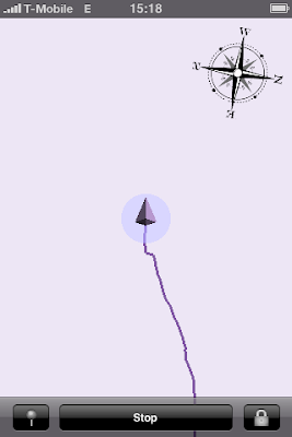
The main visible changes are:
- All new UI with graphical track view at the main screen. It is OpenGL based, you can scroll it with a swipe, zoom with a pinch, changes of current location and position accuracy are animated. The original scale is 1 pixel per meter (the scale ruler is to be added in an update, read below). To return to the original scale and position double tap on the view.
- Multiple tracks done right - with tracks list editing, number of points for each track, graphical track view, etc.
- Sending tracks per email added.
- Preliminary support for waypoints. A new waypoint can be added by taping on the 'pin' button in the logging state. It currently lacks the visual confirmation (the waypoint is initially hidden below the cursor), just don't worry, you will see that a waypoint has been placed when you move further. Additionally it is currently not possible to give a name to the waypoint.
- Support for both landscape and portrait modes throughout the application.

The less visible but important changes include:
- Application-wide handling of errors: every single operation that may fail is now guarded, and if it has failed either the user is notified (non-critical errors) or a new 'inform the developer' hidden feature comes to the light that will ask whether you would like to send me an email crash report with detailed error information (critical errors).
And now a little bit about things that are not included into the current update (but are wishful to have):
- First of all, some architectural changes have required to slightly change the database format. Though it was theoretically possible to implement a database conversion, I have decided to not do it for the current upgrade. It is nice to have but it would take too much of my resources to make it right (in a background thread with a notification when finished). For the next releases when I will already support background operations I will definitely do this, but not this time. Please upload your existing tracks before upgrading.
- It is a little bit disturbing to not have the current scale and exact location accuracy (you can asses location accuracy when in the default scale 1 meter per pixel by looking at the accuracy circle - similar as in the Maps application, but you don't see the exact number) written on the display. The reason for that is that OpenGL per se does not include support to draw strings. To draw a string in OpenGL one has to do a little of magic with patterns. I have seen an example implementation integrated in a big framework, it is not that difficult, but as I don't use any OpenGL framework I have to do it myself. Then you will also see the current scale and exact location accuracy.
- The current update still does not have a slippy map background though many other applications do. In the next quick step I'm going to enable you to see all the traces located on your iPhone for the current region - this is not exactly the map, but a step towards it. And in a future, yes, I'm going to implement local vector-based map management, not just bitmaps.
- The current support of waypoints is called "preliminary", and it is. I'm very well aware that this is a desirable feature, and I'm going to continue developing it. Including textual waypoint names, images from camera and audio recordings for JOSM audio mapping.
The update is sent to Apple for review. I will inform you as soon as it is available.


No comments:
Post a Comment